The GMA Team
Aparnna Ravi P
Doctoral Researcher
aparnnarp@iiserb.ac.in
Hello. I am working on quantifying the effect of Monsoon dynamics on carbon balance over India by utilizing high resolution modeling and observation datasets. My interested research areas include intra-seasonal and inter-annual variability of monsoon and its prediction, air sea interaction and influence of GHGs on climate change. I am a post graduate in Meteorology from the Department of Atmospheric Sciences CUSAT and Bachelors in Mathematics from Sree Sankara College Kalady under MG university. I qualified CSIR-NET Lectureship of December 2017. I have done my M.Sc dissertation in IITM, Pune on the topic “ Observational diagnostics of the breaks of Indian summer Monsoon” under the guidance of (Smt.) Dr.Susmitha Joseph. I have done summer internship as an IAS fellow in IITM,Pune under the guidance of Dr. Guffran Ullah Beig on “Heat waves” . Thanks for visiting my profile.

Vishnu Thilakan M
Doctoral Researcher
vishnutm@iiserb.ac.in
Hello. My research interests are in the applied aspects of fluid dynamics relevant to the study of the ocean and the atmosphere.
Here my research focus is on the source-sink estimation of the CO2 in the Indian subcontinent utilizing observations and
high resolution modeling. This is a very interesting topic as Indian sub continent is one of the largest emitter of green house gases
still continue to be a least explored area.
List of Publications:
- Thilakan, V., Pillai, D., Sukumaran, J., Gerbig, C., Hakkim, H., Sinha, V., Terao, Y., Naja, M. and Deshpande, M.: Potential of using CO2 observations over India in a regional carbon budget estimation by improving the modelling, ACP, 24, 5315–5335, 2024, https://doi.org/10.5194/acp-24-5315-2024
- Thilakan, V., Pillai, D., Gerbig, C., Galkowski, M., Ravi, A., and Anna Mathew, T.: Towards monitoring the CO2 source–sink distribution over India via inverse modelling: quantifying the fine-scale spatiotemporal variability in the atmospheric CO2 mole fraction, Atmos. Chem. Phys., 22, 15287–15312, https://doi.org/10.5194/acp-22-15287-2022, 2022. https://doi.org/10.5194/acp-22-15287-2022
- Samanta, D., Hameed, S. N., Jin, D., Thilakan, V., Ganai, M., Rao, S. A., & Deshpande, M. (2018). Impact of a Narrow Coastal Bay of Bengal Sea Surface Temperature Front on an Indian Summer Monsoon Simulation. Scientific Reports, 8(1), 17694. https://doi.org/10.1038/s41598-018-35735-3
- Hameed, S. N., Jin, D., & Thilakan, V. (2018). A model for super El Niños. Nature Communications, 9(1), 2528. https://doi.org/10.1038/s41467-018-04803-7
Eldho Elias
International Doctoral Researcher in collaboration with Max Planck Institute of Biogeochemistry
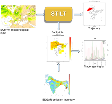
Quantification of the spatio-temporal distribution of greenhouse gases (GHG) is highly essential for any climate change mitigation policy. Over India, due to limited network coverage of well represented measurements, these quantifications often rely on book-keeping methods, surveys, etc. This causes large uncertainty to carbon budget estimation, often as high as ~100-150%. This limitation of poor-constraint with observations can be improved by enhancing the network density of measurements. In this study, a diagnostic tool called STILT is used to assess the capability of ground based observations (continuous measurements of GHG emissions with a large scale of representativeness) to deduce changes in GHG emissions as well as its natural sinks over India. This study aims at designing a dense atmospheric measurement network for India which would maximize the representativeness of measurements, by following a cost effective strategy. The network coverage over the Indian subcontinent is quantified and the ability of measurement sites in detecting flux variations are also studied. The causes of uncertainties along with the potential expansion of the study are also discussed.
Selected publications
- Kariyathan, T., Pillai, D., Elias, E. and Mathew, T.A., 2020. On deriving influences of upwind agricultural and anthropogenic emissions on greenhouse gas concentrations and air quality over Delhi in India: A stochastic Lagrangian footprint approach. Journal of Earth System Science, 129(1), pp.1-15.https://link.springer.com/article/10.1007/s12040-020-01453-6

Alumni


Gokul U K
BS-MS Project Student 2020-21
(MS Student, University of Hamburg, Germany)
The quantification of fossil fuel CO2 emission to the atmosphere is necessary for the better understanding of the carbon cycle at various levels ranging from regional to global. For developing mitigation strategies to reduce carbon emission, we need a proper estimate of the source-sink distribution of CO2 which in turn requires the monitoring, reporting and quantification of FFCO2 emission. Emission inventories are the fundamental sources of data that report the amount of anthropogenic emissions. Due to the unavailability of FFCO2 observation systems at a national level and regional estimation programs, India is completely dependant on internationally available global emission inventories. The uncertainties in these emission inventories are historically neglected due to various reasons, while huge dissimilarities among the datasets exist. In this study, we have estimated the uncertainties in anthropogenic emissions by using four global emission inventories : ODIAC, FFDAS, ICOS-COFFEE and EDGAR. We have analyzed the spatio-temporal variability in uncertainties over India. The dissimilarities in spatial and temporal representation of emission values among the datasets are quantified using graphical, numerical and cartographic approaches. The spatial analyses conclude an average dissimilarity of 77.54% at a 0.5 ◦ spatial resolution in India. Emission profiles over five highly populated city regions and thirty high emitting point sources are investigated separately for more detailed understanding of Indian emission scenarios. Over Delhi city up to 104% dissimilarity in the emission estimates are observed among inventories. An atmospheric transport model, the STILT is used to quantify the effects of these mismatches in the atmospheric mixing ratio estimates. This study reveals that the mismatches among the emission inventory is causing huge uncertainties in the mixing ratio estimates also. Over the five selected cities, an average of 34.41% overestimation and an average of 23.89% underestimation from the mean was observed when COFFEE and EDGAR datasets were used as the prior estimates, respectively. The uncertainties over major cities points to the necessity of having high resolution emission estimation systems for FFCO2 in India.

Pratik Sawale
BS-MS Project Student 2020-21
Producing maps of the agro-ecological landscape are one of the applications of remote sensing for agricultural innovations. Agricultural monitoring and smart farming for alleviating food security problems require reliable crop maps at a national or global scale for field area statistics or insurance markets. This study proposes a method to identify the crop type based on vegetation indices in the region of Bhopal District using machine learning (ML) models like Classification and Regression Tree (CART), Random Forest (RF), and Support Vector Machine (SVM). Collection of satellite data and image analysis was performed using Google earth engine (GEE), a cloud-based platform. The method includes three steps. First, a preliminary LULC (Land use Land cover) map is produced using high-resolution Sentinel-2 image processing to identify land cover types. Second, a methodology was developed using NDVI (Normalized difference vegetation Index) and GP (Greenest pixel) to identify croplands. Image classification is carried out using a Machine Learning algorithm for the remaining crop field pixels. Finally, we performed an accuracy assessment to compare the classification results of all three ML algorithms. We found that the ML model run based on 100 % training polygons leads to the highest overall accuracy of 99% by CART, followed by RF (86%) and SVM(86%). The kappa coefficients indicating classification precision for CART, RF, and SVM were 0.96, 0.86, and 0.77, respectively. The results prove that this approach can significantly improve the classification precision which demands less computational power than other traditional methods used.

Ashique V
BS-MS Project Student 2018-19
(PhD Student, Leibniz Institute of Atmospheric Physics, Germany)
Biomass burning has been a topic of scientific interest due to the implications for climatic change as a result of landscape change, loading of aerosols and trace gases in the atmosphere. The in-situ measurement and model studies of aerosols and trace gases indicate a significant contribution from biomass burning sources in different parts of India. A lionshare of Indian farmers are still engaged in agricultural residue burning due to lack of financially viable alternatives. But since crop residue burning is a practice prohibited by law in India, official surveys conducted to estimate the gravity of the situation will falter. The alternative, but efficient way to accurately determine the exact location and extent of fires is to have a global perspective of fire and associated emission from space, making space-based measurements extremely important. The objectives of the present study are to identify the regions that are affected by the biomass burning, deduce its seasonal dependence and assess the potential of GHG satellite measurement on inferring this information towards its quantification. The regional and seasonal patterns of fire count data detected over India have been analysed. For this purpose, the inventory data (GFED, EDGAR, GFAS) and satellite data measurements (OCO-2 and MOPITT) and CAMS model simulations are utilised. The overall goal of the entire effort is to explore the potential of satellite measurements in detecting biomass burning over the Indian sub-continent and their concurrent estimation. Estimating the exact locations of residue burning hotspots using space-based measurements can help in designing mitigation policies where the farmers over these areas are given access to these economically stable techniques.

Nikhila Gollakota
BS-MS Project Student 2018-19
(PhD Student, Texas A & M University, Texas)
Precise knowledge of sources and sinks of CO2 is necessary to assess its contribution to climate change. This knowledge is essential to identify possible sequestration or emission management options. Inverse modelling via atmospheric transport models is used to derive information on surface CO2 fluxes from measurements of atmospheric CO2 concentrations. To retrieve the spatial and temporal patterns of greenhouse gas surface fluxes via inverse modelling, atmospheric transport needs to be accounted for. Airborne measurements done via aircraft campaigns are needed to budget the CO2 sources and sinks besides being used to guage the elements of modelling frameworks. Along with airborne measurements, ground-based measurements are also needed to validate the measured CO2 concentrations. The atmospheric transport operates at mesoscale (10 to 20km) and significantly impacts the flux variability. These variations occur at scales that are not resolved by the current global transport models. Hence, any errors caused due to improper realization of atmospheric transport will contribute to the uncertainty of inferred fluxes via inverse modelling. To account for this variability and reduce uncertainty, the atmospheric transport model and their components have to be carefully designed such that they can resolve fine scale variability of transport. This thesis presents an inference on the spatial and temporal variability of CO2 concentrations which takes into account the airborne and ground-based measurements on a regional scale. Further, the ability of present generation global transport models to capture the concentration variability of CO2 is examined. A quantitative comparison between observed atmospheric CO2 concentrations and CO2 concentrations generated by the Carbon Tracker and Tracer Model is carried out in order to explore the extent of the current global transport models to capture the concentration fluctuations.

Theertha K
BS-MS Project Student 2018-19
(PhD Student, Max Planck Institute of Biogeochemistry, jena)
The atmospheric transport that operates at fine scales (e.g. 2 km) modify the upstream fluxes significantly. These upstream influences are often categorized to be noisy due to the improper representation of atmospheric transport at these scales in most models. However the coupling between a Lagrangian particle Dispersion model, STILT (Stochastic Time Inverted Lagrangian Transport model) and a Numerical weather prediction model (ECMWF) has shown the potential to derive the upstream influences on the measurement location by simulating turbulence and resolving the sub-grid scale transport. We use STILT with assimilated ECMWF data as the meteorological constraint to identify the influence region and to determine the sensitivity of Delhi (Latitude: 28.61° E, Longitude: 77.20° N) urban regions to nearby emissions during the agricultural burning seasons (pre-monsoon and post-monsoon). This is achieved through analysis of the footprint simulations of the receptor (measurement location) in the concerned periods. We further explore the potential of the output footprint measurements in concentration measurement of green house> trace gases when coupled to a global emission flux inventory, EDGAR.
Selected Publications:
- Kariyathan, T.,Pillai, D., Elias, E. and Mathew, T.A., 2020. On deriving influences of upwind agricultural and anthropogenic emissions on greenhouse gas concentrations and air quality over Delhi in India: A stochastic Lagrangian footprint approach. Journal of Earth System Science, 129(1), pp.1-15.https://link.springer.com/article/10.1007/s12040-020-01453-6


Yadu S
BS-MS Project Student 2017-18
The current estimates of regional carbon budget over India possess significant uncertainties due to many factors including erroneous representation of anthropogenic and biospheric contributions and improper accounting of complex atmospheric transport mechanisms. The objective of this study is to optimally design a regional greenhouse gas (GHG) modeling framework over the Indian subcontinent that results in significant reduction of biases in theestimates, taking into account of possible biases and its effective treatment. This novel scientific approach will take into account the fine scale transport and flux variability, which are not resolved in current coarse resolution global models, especially over the Indian subcontinent. As an initial study towards this long term overall goal, this study focuses on designing and implementing a dedicated modeling system for generating high-resolution carbon dioxide (CO2) simulations with a 6 km grid spacing domain over the Indian subcontinent. The proposed modeling framework consists of a coupled modeling system, WRF-GHG (a weather forecasting model coupled with a greenhouse gas module) as the core component. The domain is centered at (23.3° N, 77.4° E), which is near Bhopal, Madhya Pradesh, India. The Lambert Conformal map projection was chosen for the model domain. For implementing the modeling system, the initial and lateral boundary conditions for CO2 fields are prescribed from a global model ECMWF (European Centre for Medium-Range Weather Forecasts). The essential CO2 fluxes, both biospheric and anthropogenic, are obtained from the Vegetation Photosynthesis and Respiration Model (VPRM) and the EDGAR inventory respectively. All these models/components were explored in great detail, and coordinated in this study.