|
Modelling earth system processes involve interactions between oceans, atmosphere, cryosphere, land surface dynamics, and human systems. Earth system models encompass all the theses components and more. Regional scale such processes are essential to understand the climate variability and change for regional impact studies. Such models setup will provide a framework for regional assessment of climate change impacts for adaptation and mitigation strategies. Such framework will also provide an opportunity to quantify the uncertainty associated with modelling chain in regional climate change projections. Within the framework of CORDEX a regional earth system model is being developed for CORDEX South-Asia domain for climate change studies. Figure shows the climate modelling chain to dynamically downscale climate change scenario over South-Asia. |
The REgional atmosphere MOdel REMO with ~50km horizontal resolution is dynamically coupled to the MPI global Ocean-sea ice Model MPIOM with increased resolution over the Indian Ocean (up to 20 km). The global Hydrological Discharge model HD, which calculates river runoff (0.5º horizontal grid resolution), is coupled to both the atmosphere and ocean components. Hereafter this coupled system will be called as ROM. Figure shows grid configuration of RESM setup: the red "rectangle" indicates the coupled domain black lines indicate the grid of the MPIOM. For the ocean/sea ice grid only every 15th line is shown. The models are coupled via the OASIS coupler. The components of regional earth system model are discussed below. |

|

|
|
|
|
|
The proper description of cryospheric processes is essential for simulating the complete terrestrial water cycle in climate models. So far, the terrestrial cryosphere is represented in an extremely simplified way in most state-of-the-art global and regional climate models (GCM and RCM) as they use Static Glacier Masks, i.e. (i) no changes in ice extent, no feedback to atmosphere; (ii) no consideration of water volume stored; (iii) no/simplified runoff generation; (iv) exception: ice sheet models in ESM. Therefore, more sophisticated approach is necessary (i) if contribution of glacial melt-water to runoff, sea level rise is important; (ii) regional climatic changes in glacierized areas are to be assessed focus on discharge in glacierized river basins (Kotslarski et al., 2010). In REMO a dynamical glacier scheme (DGS) is implemented. DGS have unique ability to simulate the glacier mass balance and dynamically adjusted surface fraction of the each grid box depending on the accumulation and ablation conditions, accounting for direct physical feedback mechanisms. It is applicable for entire mountain ranges and computationally effective, target resolution: RCM grid cell. The coupled model system is referred to as REMOglacier. The scheme represents surface glacier cover on a subgrid scale and calculates the energy and mass balance of the glacierized part of a grid box. In each time step the full surface energy balance of the glacierized fraction is computed according to: dQice/snow = K+L+H+LE+G+M |
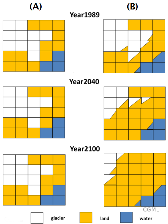
(B) More sophisticated approach |
|
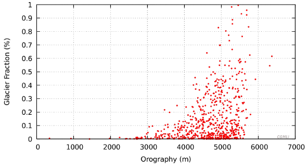
REMOglacier is first applied over the region using reanalysis data to test the model quality (Kumar et al., 2015). Figure shows the glacier fraction in REMOglacier gridbox with topography. |